Home
|
About Me
|
Portfolio
|
Services
|
Products
|
Contact Me
|
Alabama
|
Alaska
|
Arizona
|
Arkansas
|
California
|
Colorado
|
Connecticut
|
Florida
|
Georgia
|
Hawaii
|
Idaho
|
Illinois
|
Indiana
|
Iowa
|
Kansas
|
Kentucky
|
Louisiana
|
Maine
|
Maryland
|
Massachusetts
|
Michigan
|
Minnesota
|
Mississippi
|
Missouri
|
Montana
|
Nebraska
|
Nevada
|
New Hampshire
|
New Mexico
|
New York
|
North Carolina
|
North Dakota
|
Ohio
|
Oklahoma
|
Oregon
|
Pennsylvania
|
South Carolina
|
South Dakota
|
Tennessee
|
Texas
|
Utah
|
Vermont
|
Virginia
|
Washington
|
West Virginia
|
Wisconsin
|
Wyoming
|
CA Alberta
|
CA British Columbia
|
CA Manitoba
|
CA Newfoundland-Labrador
|
CA New Brunswick
|
CA NW Territories
|
CA Nova Scotia
|
CA Ontario
|
CA Prince Edward Island
|
CA Quebec
|
CA Saskatchewan
|
CA Yukon
|
Russia
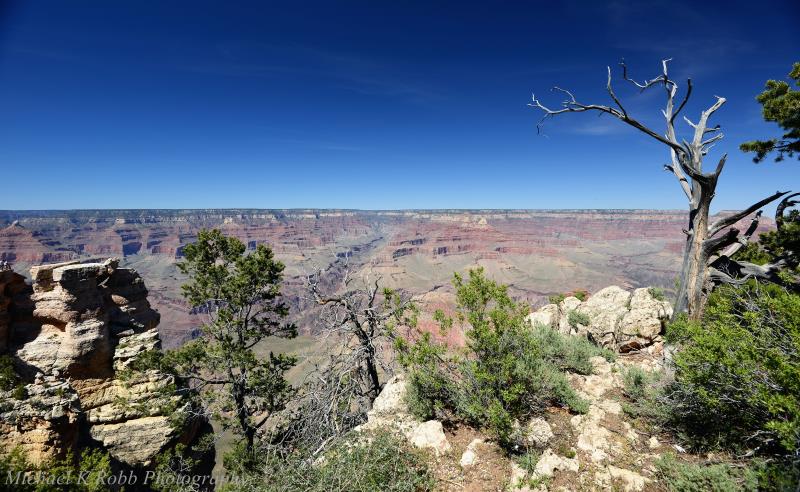
Arizona
Copyright Michael K Robb 2021


")


-near Roosevelt, Arizona")
")


")

")


Pipe Springs.")


Pipe Springs, Arizona.")

Pipe Springs, AZ.")

Pipe Springs, AZ.")

.")

.
Near Jacob Lake, AZ.")

\"winding descent\"
Near the Vermillion Cliffs.")

US 89(ALT).")


Arizona's
Vermillion Cliffs.")


Marble Creek, Arizona.")

.")

 overpass.
Marble Canyon.")


.")

Navajo Tribal Park, AZ.")

Navajo Tribal Park.")


Late-January.")


Ajo, Arizona.")

Ajo, Arizona.")

")

Ajo, AZ.")


")


In early April.")


Joseph City, AZ.")


Old Route 66
Joseph City, AZ.")


Holbrook, AZ.")

At Promentory Point.")


")


")


")


Two Guns, AZ.")


Two Guns, AZ.")


Chloride, AZ.")


Chloride, AZ.")
")


Chloride, AZ.")


Oatman, AZ.")


Along old Route 66.
Near Kingman, AZ.")


Oatman, AZ.")


Quartermaster Viewpoint.")

")

")
")


")
")

")


")


")


 ruins.")


")
")


")


Jerome, AZ.")


Jerome, AZ.")


")


")

Lochiel, AZ.")


")
")
")
")


Tucson, AZ.")

Tucson, AZ.")

Tucson, AZ.")


-Painted Desert.")
-Painted Desert.")

-Painted Desert.")
-Painted Desert.")
-Painted Desert.")
-Painted Desert.
Balanced Rock.")
-Painted Desert.")
-Painted Desert.")
-Painted Desert.")

")
")
")
")
-Painted Desert.")
-Painted Desert.")
-Painted Desert.")
-Painted Desert.")
-Painted Desert.")

